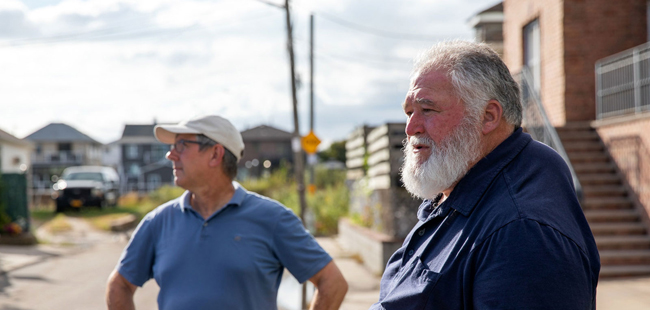
Associate Professor Brett Branco, left, with Hamilton Beach resident Roger Gendron.
Contact:
Katie Graziano, NYSG Coastal Resilience Extension Specialist, E: kag247@cornell.edu, P: 718-951-5415
— Filed by Jamilah Simmons (with additional reporting by Siobhan Boyle) for Brooklyn College Magazine [in Features section] (Volume 9, Number 2)
A multidisciplinary team of researchers—powered in large part by citizen scientists—joins city agencies and other prominent climate organizations on the front lines of urban coastal resilience planning.
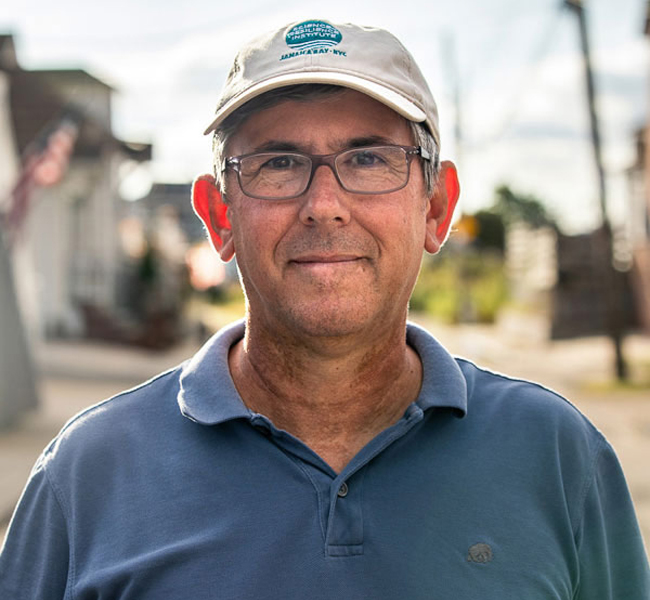
Brooklyn, NY, November 15, 2021 - Roger Gendron, president of the New Hamilton Beach Civic Association, stands in the middle of a dead-end street on a recent October afternoon. He’s roughly equidistant from his home, a stubborn patch of phragmites—an aggressive wetland grass that has naturalized on his block in recent years—and another new addition to the neighborhood: a sensor mounted to a PVC pipe that’s fastened to a Verizon utility pole.
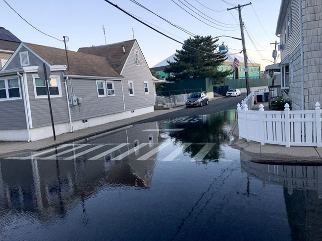
The Hamilton Beach neighborhood in Queens, where “sunny day” flooding has picked up precipitously in recent years.
He waves at a neighbor who drives by—he was born and raised in Hamilton Beach, as were many of its residents—while also pointing to a road just across Hawtree Creek, a Jamaica Bay tributary that sent its marsh water gushing onto these streets over the weekend.
“Russell Street got about four inches of flooding on Saturday,” he explains matter-of-factly to Brett Branco, an associate professor in the Earth and Environmental Sciences Department. “Four hours after high tide, there was still water.”
It’s partly Gendron’s ground game combined with his civic enthusiasm and deep personal history with the Hamilton Beach neighborhood—a stretch of 10 blocks off 104th Street built on wetlands just a few miles west of JFK International Airport—that makes the data Branco can collect from this low-lying Queens enclave a gold mine.
Brett Branco, associate professor of earth and environmental sciences
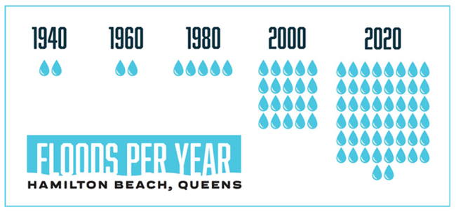
Branco is also the director of the Brooklyn College–based Science and Resilience Institute at Jamaica Bay (SRIJB), which last year received $40,000 from a new CUNY grant earmarked for climate research, to deploy sensors that measure the sunny-day flooding in a few coastal neighborhoods off the bay. A rising sea level around New York City’s 520 miles of coastline has meant a precipitous uptick in the frequency and intensity of what’s known as “nuisance flooding,” or the temporary inundation of floodwater on local streets brought on by high tides, especially around full and new moons.
“What we know for sure is that sea levels will continue to rise over the next 50 years, and more and more people will be impacted,” says Branco. “We’re trying to help improve and refine flooding forecasts so residents and other stakeholders have more specific information about a community or a block that can be useful to them to decrease the impact of flooding on their lives.”
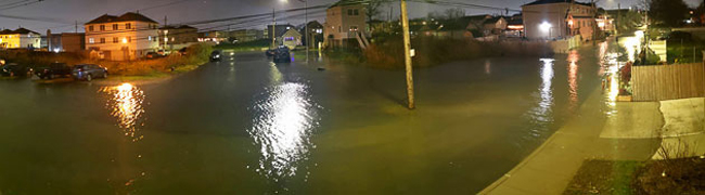
Flooding in Broad Channel, Queens.
A Flood of Data
The Interdisciplinary Climate Research Grant program, the CUNY funding, provides seed money for climate-focused research that has the potential for expansion and larger-scale funding from outside sources. It also aims to foster cross-disciplinary and cross-CUNY collaborations.
So along with Emily Tumpson Molina, an associate professor of sociology and the director of the Center for the Study of Brooklyn, and Rebecca Boger, an associate professor of earth and environmental sciences who heads the college’s Urban Sustainability program, Branco recruited Ricardo Toledo-Crow of CUNY’s Advanced Science Research Center.
Toledo-Crow’s lab, based at City College, designed the sensors, which constantly send a sonar beam down the shaft of the PVC pipe to measure floodwater. The project, known as FloodNet, has blossomed into a collaboration with the New York City Mayor’s Office and a research team at New York University. The CUNY team currently has two sensors on streets in Hamilton Beach, one in Rockaway Beach, and designs for others in parts of City Island and Broad Channel.
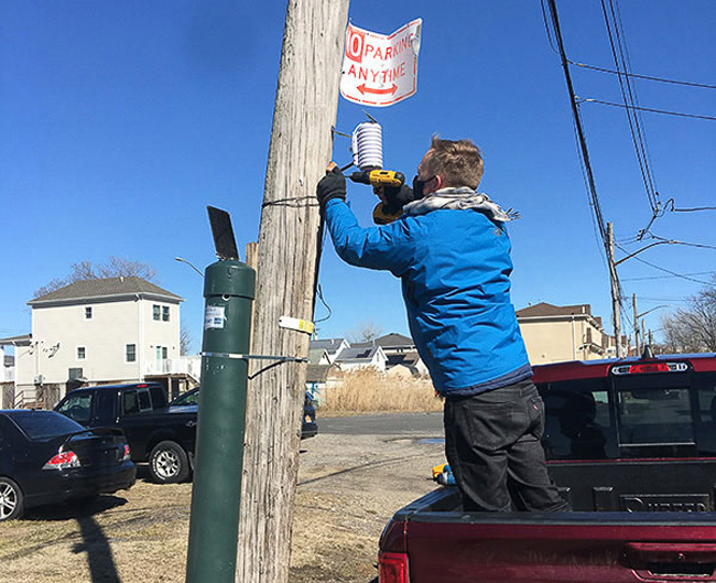
Researchers install one of the FloodNet sensors.
The team compiles that data with tidal records and tons of other information that come in from its three-year-old sister program at SRIJB, the Community Flood Watch Project, a partnership with New York Sea Grant in which local residents send in photos of flooded areas with information like the time of day, the exact location, and the depth of the water, if known. In each of the neighborhoods—where they have been developing deep ties with residents and local sustainability advocates and organizations—they’re documenting the frequency, duration, severity, and impact of flooding events. It’s all information that would be extremely helpful to policy makers who conduct resilience planning. Despite that, comprehensive, systematic, street-level data has mainly been non-existent.
Branco’s working on that part. From its inception, SRIJB has partnered with city agencies—most notably, the New York City Mayor’s Office of Climate Resiliency and the New York City Mayor’s Office of the Chief Technology Officer—to share data and provide input on broader sustainability planning and priorities. The city resiliency office has also been an official partner on FloodNet and Flood Watch, so Branco began attending monthly meetings with city officials and representatives from other sustainability organizations.
In one meeting that occurred the day after the remnants of Hurricane Ida poured into subways and killed at least 45 New Yorkers, the FloodNet team had the opportunity to share the data their sensors picked up during the storm. City leaders were impressed. (In the wake of the category 4 tropical cyclone, Mayor Bill DeBlasio committed more than $2.7 billion in new and accelerated funding to combat the effects of extreme weather and rising sea levels.)
“We have been having discussions with the city about the possibility of getting funding to expand the sensor network with their help,” Branco says. “They’re now very interested in building it up because they see the value of having all these data during these types of events. The issue is kind of catching fire.”
Science for the People
While there are a handful of similar local sensor projects by researchers across the country that have popped up in recent years, there are few that do it with the aim of activating citizen scientists the way the Brooklyn College project does.
This is where Tumpson Molina comes in.
“As a social scientist, I ask different questions,” she says. “I’m helping to plan the community engagement process, which mostly involves asking the stakeholders how we can help them collect the data they need and finding ways to merge the knowledge systems so that we get all the right perspectives into the discussion.”
Tumpson Molina worked with one Ph.D. student from the CUNY Graduate Center and two undergraduate interns from the college’s Urban Sustainability program whom FloodNet was able to hire with its CUNY funding. They primarily worked on the strategy to engage the community and conducted research on how the different neighborhoods benefit from the technology.
That meant helping to organize and monitor questions during community forums, asking residents what questions they’d like to see researchers answer, strategizing on best practices to engage virtually during the pandemic, and getting the word out to residents about the project.
“The standard scientific practice has been that the experts do the research and the community is not involved,” explains Tumpson Molina. “In this structure, community scientists get input on what the actual research questions are. It’s a very different way of going about a project like this.”
Yamilka Portorreal ’20 continued interning with FloodNet even after she graduated last December and got to help install a few of the sensors as well as work on community engagement.
“It has been wonderful to be part of a project that is designed with citizen scientists in mind,” says Portorreal, who plans to attend graduate school for soil science or sustainability studies. “It gives the community ownership of the research because they are part of the team. They’re not just passive.”
The residents, in turn, make the data come alive. And they have lots of pragmatic ideas researchers can pass on to policy makers, like coming up with a mobile alert system or flashing lights on street signs to alert travelers of impassable roads. They can also give voice to the personal reasons many of them are not willing to just pick up and leave despite skyrocketing insurance costs and now regular disruptions to their lives.
Participating in this process “makes the locals feel useful,” says Gendron. “It’s a way for us to vent and to feel empowered.”
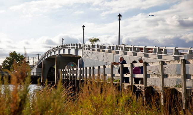
A salt marsh sits just below a pedestrian bridge in Hamilton Beach.
The scholars on the project are running on that fuel, hoping to secure additional funding to flood New York’s coastal neighborhoods with their sensors and create a stream of data that can be useful to policy makers and residents alike.
“The more data we can collect and share, the more pathways we build to turning the information into action,” says Branco. “The ultimate goal is for the flood sensor network to speak for communities across the city.”
More Info: New York Sea Grant
New York Sea Grant (NYSG), a cooperative program of Cornell University
and the State University of New York (SUNY), is one of 34 university-based
programs under the National Oceanic and Atmospheric Administration’s
National Sea Grant College Program.
Since 1971, NYSG has represented a statewide network of integrated
research, education and extension services promoting coastal community
economic vitality, environmental sustainability and citizen awareness
and understanding about the State’s marine and Great Lakes resources.
Through NYSG’s efforts, the combined talents of university scientists
and extension specialists help develop and transfer science-based
information to many coastal user groups—businesses and industries,
federal, state and local government decision-makers and agency managers,
educators, the media and the interested public.
The program maintains Great Lakes offices at Cornell University, SUNY
Buffalo, SUNY Oswego and the Wayne County Cooperative Extension office
in Newark. In the State's marine waters, NYSG has offices at Stony Brook
University in Long Island, Brooklyn College and Cornell Cooperative
Extension in NYC and Kingston in the Hudson Valley.
For updates on Sea Grant activities: www.nyseagrant.org has RSS, Facebook, Twitter, Instagram, and YouTube links. NYSG offers a free e-list sign up via www.nyseagrant.org/nycoastlines for its flagship publication, NY Coastlines/Currents, which is published quarterly.