For more than a decade, New York Sea Grant has funded studies of Malcom Bowman's as well as other investigators in the Stony Brook Storm Surge Research Group, for which Bowman is the lead. Bowman is a professor of physical oceanography at Stony Brook University's (SBU) School of Marine and Atmospheric Sciences (SoMAS).
 Stony Brook's Storm Surge Research Group Has a Bold Plan to Protect New York City
Published in: Stony Brook Magazine
By Patricia Sarica
Experts warn that we are entering an era of extreme storms that threaten
people and places once thought protected. SBU SoMAS Professor Malcolm
Bowman says we have to start planning for the next one now.

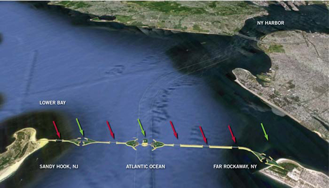
Artist’s impression of the proposed New York Outer Harbor Gateway, stretching five miles across the Sandy Hook-Far Rockaway transect. The red arrows show locations of sluice gates to allow free flow of the tides. The green arrows point to the three shipping gates that would allow vessels to pass through. Rendering courtesy of CH2M Hill.
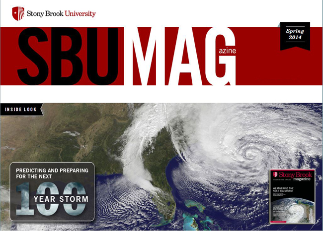
Stony Brook, NY, March 2014 - As Sandy neared U.S. landfall just south of Atlantic City on October 29, 2012, the entire eastern seaboard of the United States — from Florida to Maine — was virtually shut down. Evacuations of low-lying areas had been ordered as weather reports showed satellite pictures of the massive swirling juggernaut barreling up the coast. Meteorologists predicted epic storm surges and warned that this unprecedented weather event was capable of “rewriting the coastline.”
 Malcolm Bowman
, professor of physical oceanography and Distinguished Service Professor at Stony Brook University’s School of Marine and Atmospheric Sciences (SoMAS) and head of its Storm Surge Research Group, was at home in Stony Brook, New York, listening to news of the storm as it unfolded. For almost a decade, Bowman had been warning that such a storm would someday flood New York City. And now it was here.
In his article “
Superstorm Sandy — How Did It Happen and Are We Prepared for the Future?” Bowman recounted that evening:
“I listened to news radio at home on my hand-cranked AM radio (the power had already gone off and stayed off for a week). In horror I mentally started checking off the boxes of critical infrastructure flooded — first the Hoboken train station, then the Brooklyn-Battery Tunnel, then the FDR Drive, then the South Ferry subway station (oh my, I warned the MTA about that in a National Geographic documentary a few years ago), then there goes the East River subway tunnels…”
There had been precursors to Sandy, of course: a December 1992 nor’easter that short-circuited the New York City subway system and flooded FDR Drive; Tropical Storm Floyd in 1999, which dropped a foot of rain in 24 hours, causing flash flooding; and Hurricane Irene, which only a year earlier than Sandy had been labeled “Storm of the Century.” [
NOTE: To view Bowman's article from UUP's Febraury 2014 Magazine in its entirety,
click here (pdf)]
But what made this particular storm such a monster, and more important, can it happen again?
Timing Is Everything
Sandy was not a hurricane in the classic sense. It became a rare hybrid of a hurricane and a nor’easter, which is usually seen in winter. What made it so damaging, Bowman said, was the timing of its landfall.
“The eye of the hurricane smashed into the Jersey coast at local high tide,” he explained. “On top of that, the moon … was full, leading to a higher than normal ‘spring tide.’ The storm surge — an additional 9 feet or more of water piled up against the coast by furious winds and crashing ocean waves — was riding on top of this extra high tide.”
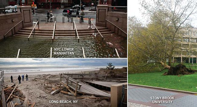
This surge poured into harbors, swept across low-lying beaches, and washed through streets.
If Sandy had made landfall during low tide — six hours earlier or six hours later — the same storm-generated surge would have produced a relatively harmless storm tide, said Bowman.
It Will Only Get Worse
Sandy was what is known as a 100-Year Storm, meaning that in any given year, there is only a 1-in-100 chance that such a storm will occur.
Yet, it was the second 100-Year Storm to hit the New York area in a year. In 2011 Irene produced heavy rainfall that drained into swollen rivers, devastating communities in New Jersey, Upstate New York and New England.
Bowman said that we can expect more extreme weather events in the future as climate change takes hold. He also emphasized that rising sea level — due to a combination of melting ice and the expansion of seawater driven by warming — means that future flooding events will be more severe than ever.
Let's Start Preparing
Sandy was a wake-up call to New York City and Long Island, Bowman told NBC News: “That means designing and building storm surge barriers like many cities in Europe already have.”
Storm surge barriers are giant floodgates that lie flat on the sea floor or retracted at harbor entrances, river mouths or coastal inlets, explained Bowman. “When an emergency is declared and before the storm hits, the barriers are rotated or slid into position and locked, acting as temporary levees.”
He cites barrier projects like those in St. Petersburg, Russia, and in the Netherlands — where much of the population lives below sea level — as models.
In 1955, a devastating storm flooded large parts of the Netherlands, drowning more than 1,800 people. Today major cities, seaports and industrial areas are protected by a series of seawalls and storm surge barriers. “If we had such barriers in place during Hurricane Sandy, there would have been no damage at all to metro New York,” said Bowman.
We can learn from the Netherlands’ example. Much of New York is less than 10 feet above sea level. The Dutch are experiencing today what New York’s fate will be in 100 years, he said.
Bowman’s Storm Surge Research Group at Stony Brook proposes that serious consideration be given to building a barrier system to protect the New York City area. One barrier would stretch from Sandy Hook, N.J., to Breezy Point, Far Rockaway. A second would be built across the upper East River to prevent surges originating in Long Island Sound from propagating through the East River into the harbor.
Opponents say such barriers wouldn’t address the real problem — the rise in sea level. The New York City Panel on Climate projects that sea levels will rise 4 to 8 inches by the 2020s.
Plus there is the environmental impact to be considered.
Christopher Gobler, professor at Stony Brook’s School of Marine and Atmospheric Sciences, said it’s hard to know what that impact would be.
“The barriers would cover a lot of marine bottom, but would also create a significant amount of underwater structure that would be colonized by many plants and animals,” Gobler said. “The value of that would depend on what colonized the structure. There also could be concerns about migration patterns of some marine life being disrupted, but it is hard to be certain.”
Other proposed measures to deal with superstorms include restoring oyster reefs (a natural feature that once protected the coast from storms), elevating buildings, and a strategy called “managed retreat,” whereby the government helps people relocate their homes when the risk of flooding becomes too high.
Next Steps
In November 2013 Governor Andrew Cuomo announced $13 million in funding for what he called “one of the first and most aggressive modifications post- Sandy” in New York — a 4,400- foot-long adjustable seawall to protect the industrial area of Long Beach, Long Island, which was badly damaged by Sandy. A feasibility study of a storm surge barrier system to protect New York City will likely be commissioned as well.
“Some people may say that storm barriers are an extreme solution,” Bowman told NBC News. “I would say it’s bold, it’s imaginative, it’s permanent in the sense that it could protect the city for another 150 years. The Europeans have done it. Why can’t we?”
