On Air, On YouTube: NOAA Predicts an Above-normal Atlantic hurricane season is most likely this year: Are You Prepared?
A May 2016 short documentary and trailer help to educate emergency managers and empower coastal communities. The videos are based on a final report from the National Oceanic and Atmospheric Administration's Coastal Storm Awareness Program (CSAP), a $1.8M effort conducted by Sea Grant programs in New Jersey, New York and Connecticut. Through CSAP, a suite of 10 social science studies were funded to help better understand how people respond to coastal storm warnings.
This 4-1/2 minute trailer for NOAA Sea Grant's Coastal Storm Awareness Program's 23-minute documentary (the latter also view-able on YouTube) points to resources from NOAA's National Weather Service, the Federal Emergency Management Agency, NYC Office of Emergency Management and more.
More on this at www.nyseagrant.org/csap, where, in addition to news and details on each of the 10 funded projects, you'll find the program's final 286-page report that these videos are based on (pdf). Additionally, there is a full-color brochure that serves as a summary of CSAP's social science studies (pdf).
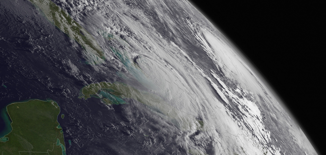
While the Atlantic hurricane season was winding down last year, many U.S. residents along the more southern portions of the East Coast faced a considerable foe in Hurricane Matthew in early October. The southeastern U.S. was then hit hard by the storm as it moved very close to the coasts of Florida, Georgia, South Carolina and North Carolina. Matthew made one official U.S. landfall on Oct. 8 southeast of McClellanville, South Carolina, as a Category 1 hurricane with 75 mph winds. While Matthew was declared post-tropical by NOAA's National Hurricane Center as it moved away from North Carolina on Oct. 9, many places from Virginia down through parts of Florida were impacted by high winds (ranging from around 60 - over 100 mph) and strong surf, storm surge and severe rainfalls (from over 5 - nearly 17 /12 inches). Savannah International Airport had their second wettest calendar-day rain on record dating to 1871 on October 7. Photo: NOAA
Above-normal 2017 Atlantic hurricane season is most likely
‘Weak or non-existent’ El Nino is a factor
Above is the full audio for May 25th's media call to announce NOAA's predictions for the 2017 Atlantic hurricane season.
Washington, D.C., May 25, 2017 - Forecasters at NOAA’s Climate
Prediction Center say that the Atlantic could see another above-normal
hurricane season this year.
For the upcoming Atlantic hurricane season, which runs from June 1
through November 30, forecasters predict a 45 percent chance of an
above-normal season, a 35 percent chance of a near-normal season, and
only a 20 percent chance of a below-normal season.
"As a Florida resident, I am particularly proud of the important work NOAA does in weather forecasting and hurricane prediction," said U.S. Secretary of Commerce Wilbur Ross. "These forecasts are important for both public safety and business planning, and are a crucial function of the federal government."
Forecasters predict a 70 percent likelihood of 11 to 17 named storms (winds of 39 mph or higher), of which 5 to 9 could become hurricanes (winds of 74 mph or higher), including 2 to 4 major hurricanes (Category 3, 4 or 5; winds of 111 mph or higher). An average season produces 12 named storms of which six become hurricanes, including three major hurricanes.
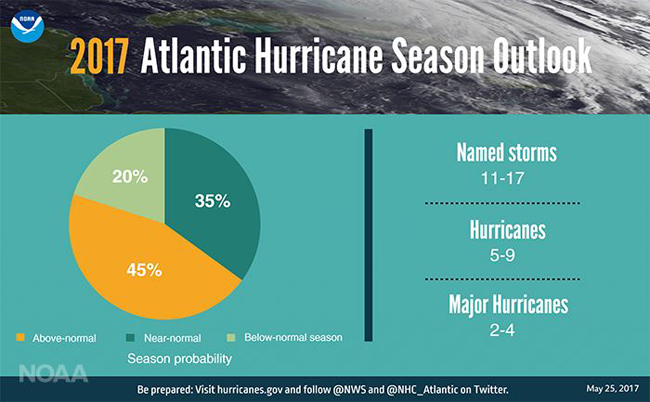
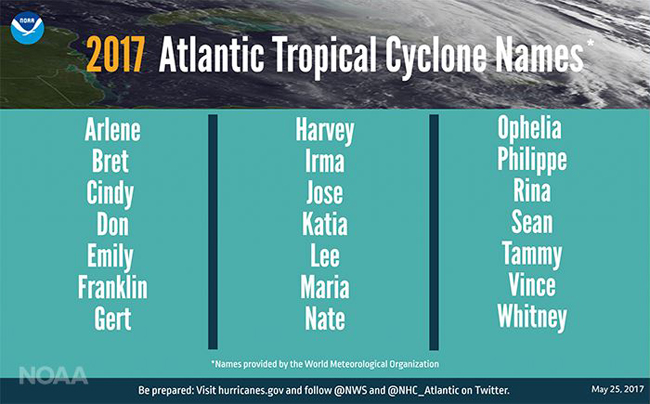
These numbers include Tropical Storm Arlene, a rare pre-season storm that formed over the eastern Atlantic in April.
“The outlook reflects our expectation of a weak or non-existent El Nino, near- or above-average sea-surface temperatures across the tropical Atlantic Ocean and Caribbean Sea, and average or weaker-than-average vertical wind shear in that same region,” said Gerry Bell, Ph.D., lead seasonal hurricane forecaster with NOAA’s Climate Prediction Center.
Strong El Ninos and wind shear typically suppress development of Atlantic hurricanes, so the prediction for weak conditions points to more hurricane activity this year. Also, warmer sea surface temperatures tend to fuel hurricanes as they move across the ocean. However, the climate models are showing considerable uncertainty, which is reflected in the comparable probabilities for an above-normal and near-normal season.
“NOAA’s broad range of expertise and resources support the nation with strong science and service before, during and after each storm to protect lives and property and enhance the national economy as we continue building a Weather-Ready Nation,” said Ben Friedman, acting NOAA administrator. “From our expert modelers to our dedicated forecasters and brave crews of our hurricane hunters, we’ll be here to warn the nation every step of the way this hurricane season.”
Dr. Gerry Bell discusses the 2017 Atlantic Hurricane Season, which runs from June 1 through November 30. Source: NOAA
NOAA brings exciting new observing, modeling, forecasting and communications tools to the table this year to improve our hurricane warning capabilities and aid public readiness:
Even before its final positioning, the sophisticated camera on NOAA’s new GOES-16 satellite will give our hurricane forecasters a sneak peek at its greater image resolution, sharp detail and rapid-refresh rate. One of the powerful instruments aboard GOES-16, the lightning mapper, will allow forecasters to see lightning strikes that build within tropical cyclones – a possible signal of strengthening.
The combination of two high-resolution hurricane models will improve forecast guidance for the National Hurricane Center this season. The upgraded Hurricane Weather Research Forecast model adds better representation of storms at higher vertical resolution, and has advanced data assimilation and improved physics. With these upgrades, the model can improve intensity forecasts by as much as 10 percent and track forecasts by as much as seven percent. NOAA’s Environmental Modeling Center also is replacing the Geophysical Fluid Dynamics Laboratory Hurricane Model with a new hurricane model called HMON, for Hurricanes in a Multi-Scale Ocean-Coupled Non-Hydrostatic, which has superior track and intensity forecast skill.
NOAA’s National Hurricane Center is providing a suite of new forecast and communication tools this season. Forecasters there will issue Storm Surge Watches and Warnings operationally this year, in addition to issuing advisories, watches and warnings for disturbances that aren’t yet a tropical cyclone but still threaten land with tropical storm or hurricane conditions within 48 hours. The center added a new experimental visualization tool so the public can easily see when damaging winds are forecast to reach their community. Also, beginning this year, the public will be able to click on the hurricane track cone graphic and see how far outside of the cone hurricane and tropical-storm-force winds extend, which can be hundreds of miles.
"Regardless of how many storms develop this year, it only takes one to disrupt our lives," said Acting FEMA Administrator Robert J. Fenton, Jr. "Get ready now with these easy, low-cost steps that will leave you better prepared and will make all the difference: Have a family discussion about what you will do, where you will go and how you will communicate with each other when a storm threatens; Know your evacuation route; tune into your local news or download the FEMA app to get alerts, and finally – listen to local authorities as a storm approaches.”
The 2016 season was the most active since 2012, with 15 named storms, including 7 hurricanes and 4 major hurricanes.
NOAA will update this outlook in early August, just prior to the peak of the season.
NOAA also issued seasonal hurricane outlooks for the eastern Pacific and central Pacific hurricane basins. An 80 percent chance of a near- or above-normal season is predicted for each region. The eastern Pacific outlook also calls for a 70 percent probability of 14 to 20 named storms, of which 6 to 11 are expected to become hurricanes, including 3 to 7 major hurricanes. The central Pacific outlook calls for a 70 percent probability of 5 to 8 tropical cyclones, which includes tropical depressions, tropical storms and hurricanes.
--
On www.nyseagrant.org ...
- Our "Trending Topics," such as climate change and green tips for coastal living, via a section on our homepage, www.nyseagrant.org.
- For the latest news from NYSG, check out our 'Currents' section, www.nyseagrant.org/currents, as well as our 'by-topic' archives, www.nyseagrant.org/currentsarchive.
- To keep tabs on all of NYSG's coastal science news, follow us on Facebook (www.facebook.com/nyseagrant), Twitter (www.twitter.com/nyseagrant) and YouTube (www.youtube.com/nyseagrant); Subscribe to our free news feeds (click the orange & white icon in the "Follow Us" navigation bar at www.nyseagrant.org); Sign up for our e-list in a few quick clicks at www.nyseagrant.org/nycoastlines. Our flagship publication, NY Coastlines / Currents, is published 1-2 times a year.